Cyclone Alfred Aftermath: Road Closures and Recovery in Tingalpa

Tingalpa and surrounding suburbs are grappling with the aftermath of ex-Tropical Cyclone Alfred, which caused severe flooding, road closures, and disruptions to essential services. Recovery efforts are underway as authorities work to restore normalcy while urging residents to follow safety advisories.


Major Roads Reopened After Flood Disruptions

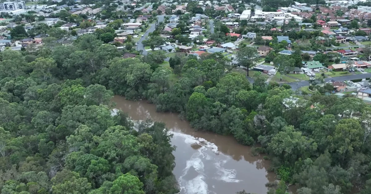
Heavy rainfall from ex-Tropical Cyclone Alfred led to significant flooding across Tingalpa, Manly, and Lota, leaving several roads submerged and inaccessible. Authorities reported multiple closures, including Manly Road between New Cleveland Road and Leon Street and key sections of Wynnum Road, Creek Road, and Murarrie Road. 

On recent news, city official Lisa Atwood confirmed that as of 2:30 p.m. on 10 March, all major roads previously closed due to flooding have now reopened. This comes after days of significant disruptions following heavy rainfall that submerged key transport routes.

Recovery in Tingalpa
Photo Credit: Skyshots Photography/YouTube

Despite this progress, localised flooding continues in residential streets, and authorities are urging residents to remain vigilant and avoid driving through affected areas.

Bin Collections and Waste Management Adjustments

Bin collections resumed across the Doboy Ward, although flood-affected areas may experience delays. Residents were advised to secure their bins to prevent them from being swept away by floodwaters. Missed collections will be rescheduled later in the week. Additionally, kerbside collection remains suspended, with flood-affected households expected to receive special pickups from Monday, 17 March.

BMD crews will provide residents with free collection services to assist with green waste removal. Local city officials encouraged residents to register via an online form.

Tingalpa flooding
Photo Credit: Skyshots Photography/YouTube

Public Transport and Infrastructure Updates

The severe weather event forced the suspension of Brisbane’s public transport network, including buses, trains, and CityCats. Limited bus services were expected to resume from Tuesday, 11 March, depending on road conditions. However, most ferry services remained suspended until further notice.

Traffic light outages at major intersections, including Wynnum Road at Kianawah Road and Bognor Street, added to congestion concerns. City officials and energy providers were working to restore electricity in affected suburbs, including Belmont, Hemmant, Carina, and Tingalpa.

Community Recovery Efforts Underway

Authorities and volunteers mobilised to assist more than 150 homes and businesses impacted by floodwaters. Local community hubs, including the Doboy Ward Office, opened their doors for residents needing power, internet access, or essential services. An evacuation centre was also set up at Sleeman Sports Centre in Chandler for those displaced by flooding.

Support for community recovery payments has been requested to the State. Further updates are expected in the coming days. In the meantime, residents requiring assistance with cleanup or waste disposal were encouraged to access council resources and volunteer programs.

Next Steps for Recovery

While major roads have reopened, residual flooding persists in residential streets. Residents were urged to exercise caution and report hazards. With forecasts predicting further rain, authorities remain vigilant, focusing on long-term recovery and mitigation strategies.

Community members are encouraged to stay updated via Brisbane City Council and TransLink for the latest transport and service updates.

Council Services and Facility Updates

BCC has announced temporary closures and disruptions across several services and facilities:

Libraries:

The following libraries remain closed:

  • Holland Park
  • Inala
  • Sandgate
  • Mt Coot-tha
  • City Archives

Libraries being assessed for reopening include:

  • Banyo
  • Corinda
  • Everton Park
  • Fairfield
  • Grange
  • Kenmore

Community Halls Closed Until Further Notice:

  • Acacia Ridge
  • Archerfield Wetlands Community Hub
  • Bracken Ridge
  • Forest Lake
  • New Inala Hall
  • Northgate
  • Sunnybank
  • Toombul Shire Hall

Pools and Recreation:

  • All pools will reopen from Tuesday, except Dunlop and Acacia Ridge pools, which remain closed.
  • Hibiscus and Langlands 25m pools remain closed until further notice.
  • All mountain bike tracks in Mt Coot-tha are closed.

Transport Infrastructure:

  • The Story Bridge footpaths are closed.
  • Limited bus services will resume from Tuesday, subject to road conditions.
  • Council Cabs will also resume from Tuesday.
  • Personalised Public Transport services are now operating.

Cemeteries:

  • Hemmant Cemetery and Crematorium remains closed.
  • Toowong Cemetery is open, but its customer service office will reopen Wednesday.

Business and Council Facilities:


  • Brisbane Business Hub (Queen St) will reopen Tuesday.
  • City Hall and the Museum of Brisbane will reopen Tuesday.
  • The South Regional Business Centre will remain closed due to site damage.

Published 10-Mar-2025

Cyclone Alfred Warning: Chandler Arena Among Shelters for Displaced Residents

As Cyclone Alfred barrels towards South East Queensland, authorities have designated Chandler Arena at Sleeman Sports Complex in Chandler as an emergency refuge shelter for residents in flood-prone and high-risk areas. The facility will be open from 7:00 a.m. to 12:00 p.m. on Thursday, 6 March, providing temporary shelter for those who have no safer alternatives as the storm intensifies.


Chandler Arena Among Emergency Shelters for At-Risk Residents

Brisbane City Council has set up three short-term shelters ahead of Cyclone Alfred’s expected landfall. Alongside Chandler Arena, RNA Showgrounds in Bowen Hills and Kedron Wavell Club in Chermside will also accept evacuees. These locations are designed as last-resort options for those unable to stay in their homes due to extreme weather risks.

Residents using these shelters should bring their own essentials, as no beds, food, or cooking facilities will be available. The facilities will provide only basic amenities, such as seating and access to drinking water. Upon arrival, all evacuees must register and present identification before being allowed entry.

Authorities have warned that once the shelters close at midday, they will go into lockdown, meaning residents should make arrangements in advance and not wait until conditions deteriorate.

Cyclone Alfred: Latest Tracking and Expected Impact

As of 1:00 a.m. on 6 March, the Bureau of Meteorology (BoM) placed Cyclone Alfred 325 kilometres east of Brisbane, moving slowly northwest at 7 km/h. While originally predicted to make landfall Thursday night, the cyclone has slowed down, and meteorologists now estimate landfall could happen Friday afternoon instead.

Forecasters warn that Alfred may intensify into a Category 3 system before impact, bringing 155 km/h wind gusts near its core. The warning area stretches from Double Island Point (north of the Sunshine Coast) to Grafton in northern NSW, with destructive 120 km/h winds expected across the entire region.

Forecasters say Cyclone Alfred is moving slower than expected, pushing back its predicted landfall and temporarily easing severe conditions on Thursday. While this gives residents extra time to secure their homes and make evacuation decisions, it also raises concerns that the cyclone could strengthen further over warm waters before eventually hitting land.

Authorities are most concerned about severe flooding, particularly in areas south of Alfred’s core. Some locations could receive 300 to 400 mm of rainfall in a single day, with total accumulations exceeding 800 mm in flood-prone regions. The storm is also expected to generate dangerous storm surges and abnormally high tides, raising concerns for low-lying coastal communities.

Current projections still place Alfred on course for South East Queensland, but officials continue monitoring for any shifts in trajectory.

Stay alert and keep track of the latest developments regarding Cyclone Alfred:

Major Flood Risks and Transport Shutdowns

Flood alerts are now in place for 6,000 properties on the Gold Coast, and authorities in northern NSW have urged residents in Pottsville, Fingal Head, and Chinderah to prepare for evacuations. In Lismore, where residents are still recovering from devastating floods three years ago, concerns are rising over whether the town’s levee system can withstand the incoming rainfall.

Meanwhile, Brisbane’s public transport system has shut down as a precaution.

  • CityCat and ferry services are suspended indefinitely.
  • Buses have ceased operations as of 6 March.
  • Story Bridge footpaths closed at 5:30 p.m. on 5 March.
  • More than 1,000 schools have been closed across the region.

Council officials have also suspended waste collection, while libraries, community centres, pools, and sports facilities will remain closed until further notice. Energex has advised that power outages could last up to two weeks in heavily impacted suburbs.

Government and Emergency Response Efforts

Authorities are mobilising emergency personnel and rescue teams in preparation for the cyclone’s impact. More than 125,000 sandbags have been distributed, while swift-water rescue teams and Australian Defence Force (ADF) personnel are on standby to assist in emergency evacuations.

Queensland Premier David Crisafulli reassured residents that critical response plans were in place, with emergency resources pre-positioned to ensure a swift recovery once conditions allow. He acknowledged Queenslanders’ resilience in the face of disasters and urged residents to take the warnings seriously.


With conditions set to worsen over the next 24 to 48 hours, residents are advised to finalise their preparations, avoid unnecessary travel, and stay updated through official emergency channels.

Published 6-March-2025